Water - Senior phase
Our freshwaters and seas are generally in good condition, and there have been significant reductions in pollution over the last 25 years.
There are still problems resulting in the loss of habitat and wildlife (both current and historic) and from water pollution, predominantly from excessive amounts of nutrients entering the water. Floods and droughts can damage our economy and wildlife and affect our health and wellbeing.
Data
Find out about Scotland’s bathing waters and beaches near you?
Use the SEPA bathing water application to find out if your beach as clean as you would expect?
Discover more data on Scotland's water environment
View the water environment hub application to see the status of the rivers, lochs, estuaries and coasts in Scotland. Find out about water levels, invasive species or overall condition.
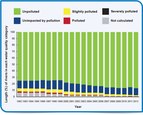
What is the trend in Scottish river pollution?
Easy-to-understand graph to show the length of Scotland’s rivers at each category of pollution. What do you notice about the trend over the past 20 years?
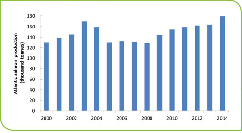
Find out about Scotland’s salmon industry
How has Scotland’s salmon industry changed over the past 2 decades? What are the reasons for these changes?
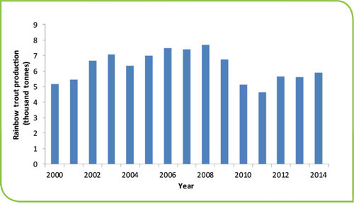
Find out about Scotland’s trout industry
How has Scotland’s trout industry changed over the past 2 decades? What are the reasons for these changes?
Find out about Scotland’s shellfish and mussels industry
Production numbers for shellfish and mussels have changed since 2003. Are these changes caused by environmental or economic changes?

Maps
Explore this flood map and areas likely to flood
This SEPA flood map shows areas which are likely to flood from rivers, the sea and surface water.
Overview map of Scotland’s rivers, coasts and lochs and their water quality
Scotland's environment map shows Scotland's rivers, coasts and lochs and their water quality. What factors are having an effect on the quality of waterways near you?
Map of major river catchment areas
Scotland's environment map shows major river catchment areas. Are your schools grounds within the catchment of a major river?
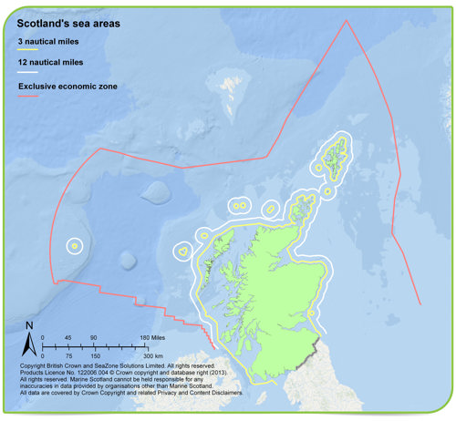
Scotland's seas
Scotland’s seas cover an area larger than its land area. This map shows the boundaries.
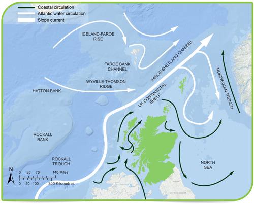
Scotland's sea water
Diagram showing Atlantic water circulation and coastal water circulation around Scotland.
Citizen science surveys
Bloomin' Algae
Bloomin' Algae Citizen scientists across the UK are being urged to help the Centre for Ecology & Hydrology (CEH) monitor harmful algal blooms which can threaten public health as well as the lives of dogs, cattle, birds and fish.
Sealife Tracker
Sealife Tracker The Sealife Tracker project aims to collect much needed data on both invasive and climate change indicator marine species around the UK coastline.
Big Pond Dip
Big Pond Dip This simple survey will allow you to do a mini health check on your pond, find out what is currently thriving under the surface and learn a bit more about what species you find.
Big Spawn Count
Big Spawn Count Citizen science project surveying the spawning patterns of amphibians in garden and school ponds.
The Great Nurdle Hunt
The Great Nurdle Hunt Look for nurdles on your local beach you can have fun and help show the local plastics industry their impact on the River Forth.
Resources
We have produced videos to help you with data sampling, collection and recording - produced in partnership with Education Scotland and OPAL (Open Air Laboratories).
Pond dipping
Watch the video on either YouTube. You can also read the video transcript (word)
Water clarity and pH
Watch the video on YouTube. You can also read the video transcript (word)
Pages we suggest
- Our environment
- Map
- Data analysis
- Get involved
Useful external links
- SEPA & Centre for Ecology & Hydrology: Choosing and using citizen science
- TCV: Citizen science - a guide for teachers
- Education Scotland: Citizen science & curriculum for excellence
- Natural History Museum & Biological Records Centre: Guide to citizen science
- Scottish Water: Education modules
- Floodline Scotland: Floodline kids
- OPAL / Education Scotland: Pond dipping (video)
- OPAL / Education Scotland: Water clarity (video)
- Met Office: Water cycle for kids