Land - Senior phase
Scotland’s land is a fundamental asset. We grow food and timber on it; we build our houses and roads on it.
Much of our water filters through and is purified by it; it stores carbon; and it supports a range of habitats and species, some of which are internationally important. Wetlands are found all over the country, with around 1,600 million tonnes of carbon stored in their peat soil.
By 2013, 18% of Scotland was covered by woodland – an increase from only 4.5% at the beginning of the 20th century. As a result of human influence and climate change, no woodlands in Scotland can be considered truly natural. Likewise, most of the uplands have been modified through grazing, drainage, forest planting and deposition of pollutants from the atmosphere, and near-natural habitats are now rare.
Data
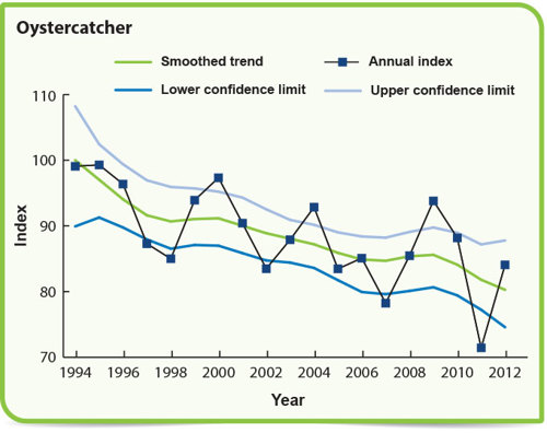
What has happened to bird populations on farmland over the past 20 years?
These graphs show numbers have gone down for these three species? Why do you think that is?
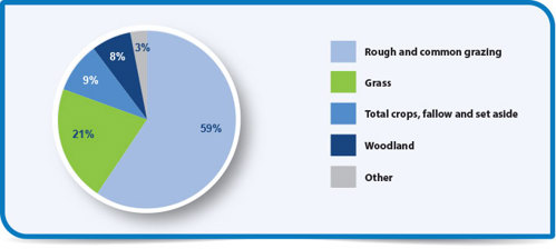
What is farmland used for in Scotland?
This pie chart show us how much farmland is used for grass, crops, woodland and grazing.
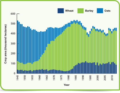
What types of crops do we grow in Scotland?
How has this changed over the past 70 years? This graphs shows the changes in wheat, barley and oats.
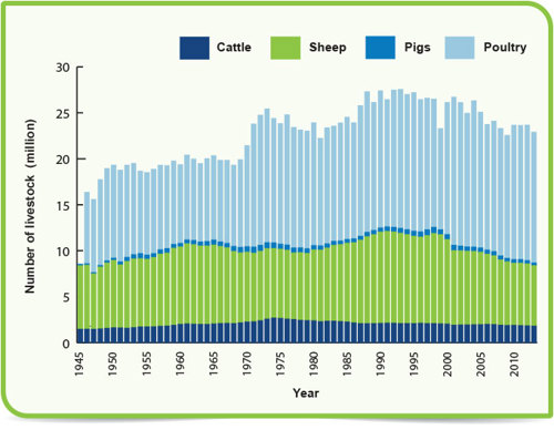
What kinds of animals (livestock) do farmers in Scotland keep?
How has this changed over the past 70 years? This graph shows the difference between cattle, sheep, pigs and poultry.
Maps
What soil type do you have in your area?
Scotland's soil map - This map shows the main soil types across the whole of Scotland. Do you have different types near you?
What habitats are in your local area?
Scotland's environment map - This Habitat Map of Scotland (HabMoS) gives details of habitats from woodlands to saltmarshes.
What species have been recorded in your local area?
NBN Atlas - Use this National Biodiversity Network (NBN) atlas to compare with your own results.
Find out if there are wetlands near you.
Scotland's environment map - Wetlands are an important part of Scotland’s environment. Use this with other maps to consider the impact of human activity on the wetlands.
Find out about listed buildings near you.
Scotland's environment map - What impact has this had on the way the urban environment has grown?
Soil texture and agriculture
Scotland's environment map - This map gives a simple overview of soil texture in Scotland. Use this to consider how this affects agriculture in your area.
What age are the rocks underneath Scotland?
Scotland's environment map - Use this map to find out about the age of rocks underneath Scotland. How does this affect the built environment in Scotland? How were these rocks formed? What does this tell us about the history of the land?
Find archaeological and historic sites
Pastmap - Use this map to locate details of archaeological and historic sites held in Scotland’s national and local historic environment records.
Find Scottish Battlefields
Scotland's environment map - Many battles have taken place throughout Scotland’s long history. Use this map to find Scottish battlefields. How did the landscape affect the outcomes of these battles?
Apps
Visit a Place
This Visit a Place app is your one-stop shop for information on Scotland’s iconic historic attractions. Packed with essential information and beautiful imagery for all Historic Environment Scotland properties.
Games and Apps
A selection of Games and apps to help learning about key conservation issues such as endangered species, climate change and overfishing.
Citizen science surveys
PlantTracker
This PlantTracker app allows you to help SEPA and other partner organisations combat the spread of the UK’s most problematic invasive, non-native plant species.
Asian Hornet monitoring
This Asian hornet app allows you to record sightings of this high-risk non-native species which is a predator of various invertebrates including pollinator insects and a threat to native biodiversity.
iRecord Butterflies
This iRecord Butterflies app is being used to monitor populations of UK's butterfly species and to see how they fare year to year. Your data will be used to inform conservation efforts to protect our butterflies
UK Ladybird Survey
Use this UK Ladybird Survey app to help The Centre for Ecology and Hydrology (CEH) and their partners record sightings of different types of ladybird from across the UK. A great app to use with younger children too.
Citizen Science apps
These free Citizen Science mobile apps from The Centre for Ecology and Hydrology (CEH) allow volunteers to quickly access information ‘on-the-go’. Using GPS and camera technology embedded in smart phones, these apps allow citizen scientist volunteers to collect verifiable records in the field. These records are used by our scientists to further our understanding of the world around us.
The Great British Bee Count
Use this Great British Bee Count app to help Friends of the Earth record bee sightings across the British Isles every year. This is a great project for schools and classes from Early Level to Senior Phase.
Tree Survey
The OPAL Tree Health Survey will help you to learn about pests and diseases affecting Britain’s trees.
Resources
In partnership with OPAL (Open Air Laboratories), Education Scotland has produced several videos to help you with data sampling, collection and recording.
Earthworms
Watch the video on YouTube. You can also read the Earthworms video transcript (word)
Measuring soil pH
Watch the video on YouTube. You can also read the Water clarity and pH video transcript (word)
Measuring tree height
Watch the video on YouTube. You can also read the Tree height video transcript (word)
Soil texture
Watch the video on YouTube. You can also read the Soil texture video transcript (word)
Sampling strategies
Watch the video on YouTube. You can also read the Sampling strategies video transcript (word)
Making the Case for the Environment - Soils
This Making the Case for the Environment - Soils (PDF) is a good 'reading for information' resource from SEPA.
Making the Case for the Environment - Organic Waste and Soils
This Making the Case for the Environment - Organic Waste and Soils (PDF) is a good factsheet from SEPA about organic composting.
Our Soil Matters - Video
The Scottish Environment Protection Agency (SEPA) has produced a series of short videos entitled, ‘Our Soil matters’. The videos feature a range of experts - representing farmers, land managers, ecologists, policy specialists, geo-archaeologists and recreational users - who are passionate about our soil environment. Each participant briefly explains why our soil is important from their own unique perspective.
How wild is the land where you live?
This map shows very wild areas in dark green. Do you have lots of woodland and areas that haven’t been changed by humans?

Wetlands are a very important habitat for many species

This Land Infographic (PDF) shows some of the impacts, benefits and pressures on Scotland's land.

Pages we suggest
- Our environment
- Map
- Data analysis
- Get Involved
- Videos
Useful external links
- Cairngorms Scenic Photo Posts
- SEPA & Centre for Ecology & Hydrology: Choosing and using citizen science
- TCV: Citizen science - a guide for teachers
- Education Scotland: Citizen science & curriculum for excellence
- Natural History Museum & Biological Records Centre: Guide to citizen science
- British Geological Survey: Discovering Geology
- The James Hutton Institute: Games and resources
- The Open Science Laboratory: iSpot
- Royal Horticultural Society: School Gardening
- Scotland's Outdoor Learning Directory